Featured post

Follow our travels

If you want to see where we've been, you can use this interactive map. Click on the markers to see more about where we have spent the ni...

Saturday, 31 August 2019

Cuddling baby huskies, visiting Santa's village and leaving the Arctic Circle


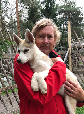
Cute heh? Who could resist the chance to see Huskies up close! After a few days on the road, today we were in Rovaniemi, the capital of Lapland, and it was time to kick back and do some tourist stuff. We visited an excellent museum, went to Santa's village, cuddled some Huskies, and ate out for the first time since Stockholm. 

We'd spent the night in one of the great little lakeside rest areas with wooden Laavu (Sami shelters) fire pits and composting toilets. The latter are useful for emptying our (chemical free) toilet cassette, but not much else. This morning we took the spaniels for a walk in the woods, where they were keen to explore smells of reindeer. Then it was on the road for the journey to Rovaniemi so that we could be at the Husky park in good time for the midday tour.

The Husky Park was at Santa's Village, a year round attraction that lacks something with no snow on the ground, but was nevertheless nicely done, and not too tacky. To our delight we were told that, after the talk and tour of the Husky area, we would be invited to be guinea pigs for the new "Hug a Husky" area that was due to open tomorrow. So we skipped the €30 per person fee, and got in there with this year's puppies.
No one had told the puppies that they were there to be hugged, and socialisation was in its very early stages, so the first challenge was to catch your puppy. They were highly delighted to be out of their pens, and their immediate priority was to run in dizzy circles with their littermates. Years of catching Jackson Spaniel when he was on one of his jaunts had taught me some skills, and I soon had one in my arms, where my ears were given a good wash. 

We could have stayed there all day chatting to the mushers and playing with the puppies and their mums, but we had our own pups to get back to, and to take for a walk around Santa's village. On our way we sadly stepped back across the Arctic Circle. Max wasn't keen, being a heavy coated sort of dog, but Elsa was ready to start moving south. It seems an age since we crossed the line northbound on a ferry off Norway. In fact it was the 7th August, only three and a half weeks ago, but so much has happened since then.
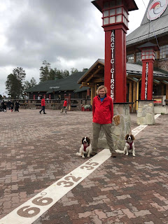
Max above the Arctic Circle, Elsa below

Santa's office, open 365 days a year

After an entertaining wander around the village, we were lured into a café, where the prospect of our first meal out since Sweden was too much for us, and we both tucked into a burger and fries. Being where we were it was probably almost as expensive as Norway, but it hit the spot after five weeks of healthy, home-cooked food.

A quick top-up with water and fuel at the Shell garage across the road, and it was back into Rovaniemi itself for the Arktikum, a museum of the Arctic. This proved to be an excellent centre of science, ethnography, natural history and art, and we could have spent a couple of days there. As it was, our brains were overloaded after a couple of hours, and we skimmed a couple of galleries, promising ourselves to do more research later. 
The Arktikum Museum
First catch your husky

Got one!


Friday, 30 August 2019

New country, different currency and a problem with time.


It was something of an anti-climax as we headed south through Finnmark. The Northern Cape had been on our target list since we started planning this trip and heading south meant retracing our steps for the first time on the journey. We filled up with LPG at Alta, the last chance we would have before reaching Estonia. Finland does not allow cars to run on LPG so bulk supplies of Autogas are not available. However, we reckon we can last two weeks with a full tank so that should be enough. 
The Alta river gorge was a fine farewell from Norway

Our journey south from Alta took us through the spectacular gorge cut by a tributary of the River Alta. The winding road ducked and dived between huge rock faces in what was to be the last chance we had to sample Norway's spectacular brand of scenery. Once through the gorge the countryside levelled out to become low, undulating hills linked by plains of scrubby bushes and small trees. In the village of Kautokieino  we stopped at the motorhome services in a supermarket car park before making our way 5km down the road to the edge of a lake for what would be our last Norwegian night on this trip. To cheer us up the sun had come out so we ate our evening meal outside despite the onslaught of Norwegian attack midges


More subdued countryside as we went south
The next morning we took the spaniels for a walk up a rough track which wound uphill through the bushes. Nothing can grow on this rocky, sandy soil and the only activity here is the herding of reindeer by the Sami people. We had become used to seeing their language appearing on road signs alongside the Norwegian. It reminded us of our trip last year through the Basque country of France and Spain where dual language signs also celebrate local culture. A quick trip back up the road to the supermarket for services and a few bits before we headed south again.

Someone's been using this for target practice

The landscape barely changed for miles and had it not been for the signs and the border post, we would not have realised we had crossed into Finland, the eighth country on this trip. Obviously cross border traffic is common here, so much so, that the first filling station we passed displayed prices in Norwegian kroner rather than the euros adopted by Finland. The North of Finland is as sparsely populated as Finnmark so we saw few other vehicles as we made our way south. The dual language signs, now in Finnish and Sami continued, the Sami people obviously consider any border irrelevant. The reindeer looked the same too.

Our first night in Finland was spent close to the river Etuvayla which, in this part of the country, forms the boundary between Finland and Sweden. We had forgotten that crossing the border entailed a change of time zone, with Finland being an hour ahead of Norway and Sweden. We were still blissfully ignorant of this by the time we stopped for the night because we both wear Apple watches which take the time from our iPhones. However, the strongest network signal was coming across the river from Sweden so technology decided we were still on Swedish time. 
1015 on the left in Sweden..1115 on the right in Finland

Common traffic hazard
Our walk with the spaniels along a rough path bordering the river took us to a couple of wooden buildings where a group of schoolchildren were waiting their turn to do some white-water rafting down the swift flowing river. We had a chat with one of the teachers who told us she had visited London and Stratford on a previous visit to the UK, when she had lived for a while in Solihull. We were able to get down the bank to the river so that Max could have a swim. he is an enthusiastic water baby.

We drove back to the town of Muonio to do our first weekly grocery shop in Finland and try to decipher the labels on the products. We had just about got the hang of Norwegian but Finnish, a language with a completely different root to other Nordic tongues, is a real challenge. On the plus side, although food is dearer here than the UK, it is cheaper than Norway. The range of products, especially fresh food, is also much better.  It says something that we were positively ecstatic that a box of wine in Finland cost 'only' 28 euros, still horrendous by UK standards but some 15% cheaper than across the border. We were delighted to see that the state wine shops are branded 'Alko'. We also discovered that diesel was priced at UK levels which was nice after four weeks of Norwegian filling stations.
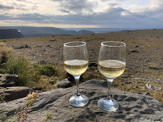
More wine

The rest of today's journey south was routine. We had  been warned that driving down through Finland would just be a succession of straight roads lined by trees and so it proved. In fact, the roads were so empty and monotonous we decided we would swap over each hour in order to fend off the boredom. We actually saw just as many reindeer as we did other vehicles. Tonight sees us parked by a beautiful stretch of water, just one of 187,888 lakes in Finland. There is unlikely to be a hosepipe ban here. 

We've stopped in worse places


Tuesday, 27 August 2019

A long walk to the real north, and some interesting finds at the fake one


Sunset at the North Cape
You left us sipping champagne on the top of a 300m high cliff watching a beautiful sunset over the Barents Sea at Nordkapp: 71° 10’ 21” N. The wind threatened an uncomfortable night, but soon died down, and we awoke to bright blue skies. After a tramp across the cliff tops with the spaniels, under the close surveillance of a herd of reindeer, we set off for the visitors centre. After all, we had paid £27 each for our 24 hours at Nordkapp, and we wanted to get our money’s worth.

Obviously nothing was going to be worth that amount, except that we’d decided long ago that we were going to swallow the cost, because, well, there is something quite special about Nordkapp. And the visitors’ centre helps to make that clear. It was given the name by an English (Devonian) sailor in 1553, and has been visited by the great and the good ever since. Earlier visitors had to arrive by boat and then make a fairly arduous climb up the cliff path. Later, a zig zag path was laid to make it easier. The road wasn’t built until 1956. 

"Who you looking at?"
As well as learning about the history of The North Cape, including a fascinating display on a visit by the King of Siam in 1907, we read about local sea birds, saw a light display on the midnight sun and northern lights, and watched a panoramic film. There was also a very good exhibit on the WWII arctic convoys, and the sinking of the German battleship, the Scharnhorst. The gift shop was an experience on its own right, although best not to look at the prices. Altogether we spent almost 90 minutes being educated and entertained. Just as well we’d brought our own champagne though: it was £17 for a 20ml plastic bottle of wine at the café. 

The path to the other North Cape
Apart from the excessive entry price, there is another reason why many who make the journey here still avoid Nordkapp. It isn’t actually the most northerly point on the island. That distinction belongs to Knivskjelloden, a peninsula stretching up to the west of Nordkapp, the end of which is only accessible on foot. 9km on foot. 18km (11 miles) if you are thinking of returning. Of course neither point is the northernmost in mainland Europe, that’s in Russia, and if you are counting islands, then surely you must count Svalbard, but the vast cliffs at Nordkapp are as good a destination as any.

All that said, the sun was shining, I wasn’t likely to be passing this way again, and there was a challenge to be met. So shortly after lunch I packed my rucksack with Marmite on Ryvita, donned my walking boots, picked up my poles, and headed off from the car park at Knivskjelloden trail head. Reading back the review afterwards I had some sympathy for those who had read that it was an “easy” walk and felt they’d been misled. The ground is rough and rocky when it isn’t boggy, a long gradual descent to the sea means a slog back up, and the last half mile over sloping rocks must be nail biting in the wet. But I had a pretty good idea what I was taking on, the trail was well marked, there were reindeer and eagles to watch. and I had good boots. I told Nick I’d be back in four to five hours, and I walked back in after four and a half, having stood at 71º 11' 08" - almost a nautical mile further north than Nordkapp. (See top photo)

The sun returns for a lovely walk
I skipped my run this morning, and after picking up supplies in Honningsvåg, we headed back through the 212m deep undersea tunnel to the mainland. The weather had clamped in overnight, and we owed the dogs a proper walk, so we were delighted when the sun came out to reveal a beautiful valley up a path from our lunch stop. After a walk, we returned to the northernmost motorhome services in Norway, last seen 48 hours before, and as fuel there was still cheap (for Norway: 14.20 NOK) we topped up the tank. Back to Alta tomorrow for our last chance to fill up with LPG before Estonia.


Sunday, 25 August 2019

Copper history, prehistoric carvings and the North remembered


Tonight finds us parked close to a cliff, looking across the Barents Sea with the cold wind howling around the van. We have finally reached Nordkapp, the North Cape, a month after crossing the border from Sweden into Norway. That crossing took place in hot sunshine, now the sky is grey, the temperature is some 20 degrees cooler and the landscape has changed to tundra. This is the most northerly point in mainland Europe that can be reached by road.

Spaniel territory
Yesterday started in Kafjord where we had overnighted after visiting the local church to photograph some Cornish graves. The research project was not yet over. After allowing the spaniels a very welcome run off the lead we set off for the site of the old copper mines where Cornish miners, who justifiably described themselves as the best hard rock miners in the world, had toiled alongside their fellow workers from Norway and Sweden. The site of the mine itself was closed off due to the risk of slipping spoil heaps, but a well-marked path took us along the edge of the fjord to the remains of the old smelting works where the copper was separated from the rock. The resulting slag was still visible, much of it having been formed into square blocks for local walls. 
The remains of the copper mine on the hill

Kafjord was also the place where the German battleship, Tirpitz, was stationed in a bid to tie up British naval forces. In 1943 she was badly damaged following a daring attack by Royal Navy mini submarines. A stone in the graveyard of Kafjord church commemorates the British officers and men who lost their lives in the attack. Tirpitz never sailed again and was later sunk by RAF Lancaster bombers. 

Our next stop was Alta where we visited the museum. Its most valuable treasure is outside the building, a large number of rock carvings dating back some four or five thousand years, a UNESCO World Heritage Site. Left where they were originally carved in the arctic climate, many have faded but some of the images of deer, bears, fish and ships have been highlighted in red paint. From there we moved on to the local church where we checked the graveyard but realised it had been built too late to have any connections with Cornish miners. Our attempt to get into the church itself was thwarted by a man at the door shooing us away because there was a wedding in progress. We paid a quick visit to a supermarket and then to the state off-licence for a much-needed box of white wine. Unfortunately it closed at 3pm. How Norwegians ever manage to drink any alcohol is beyond me. 
Rock carvings in Alta
Our progress further north saw a much changing landscape. Having spent the previous ten days on winding roads surrounded by cliff faces, we discovered that the land opened up and the hills were much lower.  Reindeer became much more common and we passed several small groups browsing in the sparse vegetation. We were now in Sami territory, the indigenous people who herd the reindeer and whose language appeared on roadsigns alongside the Norwegian, and we passed many of their wigwams and wooden houses. We overnighted in a lay-by close to a shallow river where there was plenty of space to walk the spaniels.The temperature dropped to almost zero overnight so we were glad we had broken out the extra duvet.

The spaniels have left their mark...until it rains
We had planned to make our way in the general direction of Nordkapp stop overnight and arrive on Monday morning. However, the roads were far better than we had expected, so much so that we found ourselves having lunch by a fjord only an hour away from our destination. The pebbled beach where we stopped had  a large number of stones on which people had recorded their names and countries of origin. Neri felt it was right to mark our journey by leaving one of our own. Late afternoon found us climbing over the last section of road before arriving at Nordkapp. 

We found that, like Lands End, Nordkapp is very commercialised and we were prepared for
the 500 kroner cost of getting in and staying for the night. The hit on our wallets was somewhat eased by the cheerful man at the pay point who told us he had studied at Birmingham University and lived in Worcester. With evening approaching we walked around the very high cliffs, took the obligatory photograph close to the globe that marks the Northern edge of the site, and retired from the biting wind for a celebratory glass of champagne and the rest of the reindeer fillet. Tomorrow we will see what the visitor centre has to offer and then plan to turn Florence's nose south towards Finland and the beginning of our journey to a Greek Christmas. 


Friday, 23 August 2019

Alps, reindeer and a mission to locate some Cornish emigrants


Having left the islands and Tromsø behind us, we are now finally on the last leg of our journey up to Nordkapp, the Northern Cape. First we had to turn south from Tromsø and rejoin the E6, the road from south to north in Norway, which we last saw a couple of weeks ago at Mosjøen when we left it to take the coastal road up to Bodø and the ferry to the Lofotens. 

The E6 up here goes through wilder, more muscular scenery, and we were treated to a glorious stretch up the vast Lyngenfjord, with the Lyngen Alps glowering at us from the other side. This is a 90km long mountain range with 1800m (6000ft) peaks and multiple glaciers. The mountains are now a playground for climbers and extreme skiers, but wouldn’t you know they were first climbed by a Yorkshireman: William Cecil Slingsby, the adopted father of Norwegian mountaineering. 

Glaciers everywhere you look
Some seriously high waterfalls
You can almost see the ice moving

Nick is concerned for the fate of his Poohstick
We stopped overnight at a rest area just a little way from the main road where the old road gave access to trails through woodland and moorland, and along a stream. An ideal spot for me to run, and for us all to walk up to a small lake with a picnic area. Summer may be short here, but while it lasts there are enough picnic tables scattered around the countryside for most of the population to eat outside on any given day. Of course most of them have fire pits too for when it gets colder, but they are strictly off limits during the summer months - in fact there have been forest fire warnings for much of the time we have been here. 

A breathtaking view of Kvænangenfjord 
After enjoying our walk we made a late-ish start, and found ourselves climbing quickly to a mountain pass which enjoyed spectacular views over Kvænangenfjord, another of the great fjords which stretch down from the north towards the point where Norway, Sweden and Finland all meet. There was little  more than an hours driving before we crossed the border from Troms County into Finnmark, the largest and least inhabited of Norway’s regions. No sooner had we passed the sign than I hit the brakes to avoid our first reindeer, which was standing in the middle of the road daring the traffic to come closer. We saw many more in the half hour or so before we pulled off the road. They are herded by the Sami people, and allowed to graze wild like sheep. I was just relieved to see cattle grids at the entrance to the tunnels, as I didn’t fancy meeting one in there!


Finnmark at last

Florence outside Kåfjord church
Our stop tonight was in the small town of Kåfjord, where we had a mission to undertake. Now little more than a village, Kåfjord was once a town of a thousand inhabitants, one of the biggest in Finnmark County, as there were several copper mines here. In the 1820s the mines were established by British speculators who brought over eight Cornish miners who had the expertise to extract the ore. Six of them returned home after a year, but Nick had been asked to record any evidence of those Cornish emigrants and the ones who remained. We found the church, and the graves of three children with Cornish names, and an English mine superintendent. Work is afoot to discover more, and tomorrow we’ll visit a mine site, and go into Alta, where there are rumoured to be more Cornish connections in the church there.

The young son of Charles Trenery and Ann Luckes


Wednesday, 21 August 2019

More island hopping, amazing views and a steep ascent


I like hills and mountains. The landscape in Northern Norway consists of little else but, as someone who gets a touch of vertigo on a thick carpet, I have always believed they are best viewed and admired from afar. However there are those who can't see a peak of any size without wondering what the view is like from the top. Thus it was that I found myself persuaded by the mountaineer in the family to attempt a climb above the fishing village of Sommarøy where we had just spent the night. Unusually for us we had decided to stop on a proper campsite simply because it was laundry time again and they offered a washing machine and a dryer. 

Mountains with tops like jagged teeth
It wouldn't be difficult she said. There was even a handrail. We would climb the steep way up and there was a much easier way down according to reviews she had found on the internet. It turned out that  the reviews were written by people who obviously found the North Face of the Eiger a bit of a stroll. The rocks we were supposed to ascend seemed to climb vertically from the base of the hill. The promised handrail turned out to be a long length of rope, attached to metal poles. Sometimes the rope was actually within reach of the path and some of the metal poles were still safely embedded in the rock. The spaniels took it in their stride, four paw drive is a great asset, but I confess my legs were shaking by the time I got to the top. 

This is my preferred view of the rock climb
Having risked life and limb it was somewhat ironic that, when we reached the summit, I discovered that not only was there a road to the top but a camper van had made itself comfortable alongside the defence installation that crowned the hill. The so called 'easy' path down was negotiable , although in parts I had to resort to an undignified sliding down on my rear. Never was anyone so pleased to finally get back to sea level again. 

We had previously spent two nights at the Knuten Trail Head, close to the village of Mefjord on the island of Senja. This large flat area of ground had stunning views and we decided to stay for two nights so we could do a little cleaning and allow me to carry on with some family history research for a client. Autumn has already arrived this far north of the Arctic Circle and the hot summer days we experienced in our first four weeks in Norway have turned to cooler, rainier weather. Already the leaves here are beginning to turn to red and gold and the short summer is coming to an end.

A Norwegian Puffin Dog
On a stroll through the village we met a local walking his two dogs who asked what breed Max and Elsa were. It turned out that his two were Norwegian Lundehund or Puffin dogs, bred to climb rocks and cliffs when puffins were a major part of the local diet. They have evolved to be able to climb the narrow cliff paths and are capable of bending their heads backwards along their spines and turning their forelegs at a 90 angle to their bodies. To enable them to scramble over rocks they have six toes per foot rather than the canine normal four. They can also fold up their ears to form a watertight seal. They were very friendly.

Having said farewell to Mefjord we drove down more winding roads and through narrow tunnels to the ferry at Botnhamn for the half hour journey to Brensholmen on our way to Sommarøy. This was likely to be our last ferry journey for a while, certainly until we get the boat from Helsinki to Tallinn in September. We have been grateful for our decision to take the bike rack off the van for this trip. Ferry prices in Norway are based on length of vehicle. We sail in at just under 6 metres which means we pay the same as a car. On this trip our fare was the equivalent of £31. Another few inches and it would have cost us more than £60. It pays to be short sometimes. 
The view from the top of the climb


Today we drove to Tromsø having decided to by-pass the city itself. However, a shopping centre next to the airport gave us the chance to get some more groceries and a drop more wine. We were also able to find somewhere to top up with LPG which we rely on for cooking and heating our water. We need to make sure we have plenty in the tank before we arrive in Finland. It's impossible to buy it there. Tonight finds us in a parking area on the side of the E8 road. Just for a while we have had to turn south. Tomorrow we join the E6 and change direction as we head for Nordkapp, the most northerly point in Europe accessible by motor vehicles. Time to break out the winter clothes. 

A panorama of Sommarøy


Sunday, 18 August 2019

Follow our travels

If you want to see where we've been, you can use this interactive map. Click on the markers to see more about where we have spent the night.

Blue markers just have info about the overnight.
Purple markers have a link to a blog published from that spot. 


Saturday, 17 August 2019

Island hopping in the Arctic


Tonight, Florence the motorhome is parked with her nose at the edge of a fjord on the island of Senja, the second largest in Norway outside of Svalbard. Above us is one of the fantastically over-engineered viewpoints that are scattered along the national scenic routes, in an effort to boost their tourism value. We have much the same view, and we're spending the night here, for free. 

Senja from the sea
We arrived on Senja this afternoon, after a two hour ferry journey from Andenes, on  the northern tip of Andøya. The sun shone, the sea was flat, and there were marvellous views at either end. In between we scanned the sea for whales, as they are often seen from shore here, and (fiercely expensive) whale watching trips offer guaranteed sightings. Today they were nowhere to be seen, but we enjoyed the warm sun and fresh air. As an added bonus there were hundreds of Arctic Terns at the quay in Andenes, and we'd had a great time over lunch in the ferry queue, watching them dipping and gliding like outsize swallows. 

Florence avoids being flattened
We'd spent the night just a few miles outside Andenes, near another of the architecturally designed viewpoints at Bleik. We decided it wasn't quite on to park in the lookout, so we'd found a nice spot opposite, on what looked like the old road. As long as the cliff overhead didn't come down on us in the night, we'd be fine! Fortunately it didn't, and we returned to Bleik village this morning to take the spaniels for a wander along the trails behind the dunes and along the beach - the longest white sand beach in Norway. 


The three scenic routes in this north west corner of Norway are separate, but linked. The chain of islands that runs up to the west looks like a single group, but while the southern ones belong to the Lofoten archipelago, to the north are the Vesterålen islands. The most northerly of these is Andøya, where we have spent the last three nights slowly working our way along the 50km road on the west of the island - the second of the scenic drives. If the Lofotens are like a craggier, shark-toothed version of Skye, then Andøya is like the west coast of Ireland, with the mountains of Mourne thrown in.  
National Scenic routes in Norway: Andøya
View from the top of Måtind
There are long stretches of silver-sanded beaches, and vast flat areas of peat bog, and moor - mostly fairly dry at the moment. And then suddenly a peak of almost bare rock will thrust itself up through the moor, with almost nothing in between. Yesterday we set out to climb one of them, Måtind, a lovely little mound of 408m (1300 ft) with great views at the top, and enough technical bits to make it feel like a challenge.  As before, Max found the climb quite difficult, so he and Nick took a perch in the heather while Elsa and I carried on over a tricky rock field to the top. This time we made it all the way to the cairn, and were rewarded with a stunning panorama. 

A happy climber 

A wild camp with water provided
The car park for the trail head was busy, and we met people on the path, but the island is far less crowded than the Lofotens, and doesn’t seem to be infested with tour buses offloading day-trippers to swarm over the most compelling views. Wild camping is easier, there are lots of places along the beach, like the lovely area behind a community centre where we were even able to fill up with water. 

At first glance Senja seems even quieter, we have mainly shared the road with the same people who came across on the ferry with us. There are fewer than eight thousand people living on the island, and very few roads. The centre is made up of continuous ranks of mountains, like something out of the Lord of the Rings. Our first impression was that is was more green and lush than the other islands, more like Sardinia or Corsica. But apparently Senja is Norway in miniature, and will offer every type of landscape as we move forward. As the sun sinks tonight, we're pretty happy with the one we have. 

Sheep like a day at the seaside too

The sun sets over the Arctic

Norway's longest white sand beach

Viewpoints Norwegian style